
Designed by Robert Moore


Copyright © 2005-2018 by Robert Moore · All Rights reserved · E-Mail:droceretik@gmail.com
Kite Altitude World Record

Dyneema®, the world’s strongest fiber™
September 2011 - So close, oh so close.
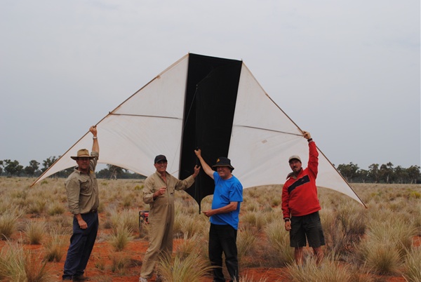
This year we stayed in the wool shed on Cable Downs as it would save the time and effort of setting up and packing up camp. It made little difference to the daily flight setup as we were only a few hundred meters from the air strip. For the third year in a row Michael Richards, Roger Martin, Michael Jenkins and me, Bob Moore, came together to attempt the world altitude record for a single kite. We are a cohesive team and we know our roles well with Mike Richards being an organiser, assembling the kites, doing everything, Mike Jenkins driving the winch and the kitchen, Roger Martin manning the Cameras and the GPS telemetry observation and me?? I guess I just put it all together and do the worrying. The last 2 years we endured heavy rain and thunderstorms which obliterated our camp site in 2009 and scared us a bit in 2010. We were glad we did go to the woolshed as gale force winds and storms played havoc with our record attempts. Despite these conditions we flew very high on day one, in fact, we nearly broke the record. On day 4 we flew very high and were heading for the record when the line broke. Our shift to September paid off with flights to 14,121 ft and 12,700 ft. These images and graphs are an account of our efforts. The 2007 <http://www.youtube.com/watch?v=-VE6Fdd0jnk>, HYPERLINK "http://www.youtube.com/watch?v=Do8L6nfQn1U" \o "2009 Kite Altitude Record" 2009 <http://www.youtube.com/watch?v=Do8L6nfQn1U>, 2010 <http://www.youtube.com/watch?v=HqJTH4an4qc> and 2011 <http://www.youtube.com/watch?v=gCQO23QtOZ4> attempts are on YouTube.


94711 Cobar Mo Observations at 12Z 28 Sep 2011
-----------------------------------------------------------------------------
PRES HGHT TEMP DWPT RELH MIXR DRCT SKNT THTA THTE THTV
hPa m C C % g/kg deg knot K K K
-----------------------------------------------------------------------------
1000.0 24
972.0 264 16.8 14.0 84 10.44 30 14 292.3 322.2 294.1
970.0 282 17.2 13.9 81 10.39 28 15 292.9 322.7 294.7
925.0 690 16.6 9.6 63 8.17 350 35 296.3 320.2 297.7
912.0 810 16.3 8.5 60 7.70 335 36 297.2 319.9 298.5
860.0 1309 15.0 4.0 48 5.96 310 54 300.8 318.9 301.9
850.0 1408 14.6 3.6 48 5.86 305 57 301.4 319.2 302.5
849.0 1418 14.5 3.6 48 5.86 305 57 301.4 319.2 302.5
811.0 1800 11.3 2.3 54 5.61 295 58 302.0 319.1 303.0
774.0 2189 8.1 1.0 61 5.36 295 57 302.6 319.0 303.5
756.0 2385 6.4 0.4 65 5.24 295 58 302.8 318.9 303.8
732.0 2650 5.8 -4.2 49 3.85 295 59 305.0 317.1 305.7
700.0 3014 2.8 -6.2 52 3.45 295 61 305.6 316.5 306.2
666.0 3414 -0.7 -9.7 51 2.76 291 64 306.0 314.9 306.5
626.0 3899 -5.0 -10.4 66 2.79 285 68 306.5 315.4 307.0
581.0 4484 -10.3 -11.2 93 2.81 294 87 307.0 316.0 307.5
578.0 4524 -10.0 -11.0 92 2.87 295 88 307.8 317.1 308.4
562.0 4741 -8.1 -10.0 86 3.20 305 68 312.5 322.9 313.1
509.0 5503 -12.2 -14.2 85 2.53 325 47 316.5 325.0 317.0
500.0 5640 -12.9 -14.9 85 2.42 330 47 317.2 325.4 317.7
-----------------------------------------------------------------------------
PRES HGHT TEMP DWPT RELH MIXR DRCT SKNT THTA THTE THTV
hPa m C C % g/kg deg knot K K K
-----------------------------------------------------------------------------
1000.0 24
972.0 264 16.8 14.0 84 10.44 30 14 292.3 322.2 294.1
970.0 282 17.2 13.9 81 10.39 28 15 292.9 322.7 294.7
925.0 690 16.6 9.6 63 8.17 350 35 296.3 320.2 297.7
912.0 810 16.3 8.5 60 7.70 335 36 297.2 319.9 298.5
860.0 1309 15.0 4.0 48 5.96 310 54 300.8 318.9 301.9
850.0 1408 14.6 3.6 48 5.86 305 57 301.4 319.2 302.5
849.0 1418 14.5 3.6 48 5.86 305 57 301.4 319.2 302.5
811.0 1800 11.3 2.3 54 5.61 295 58 302.0 319.1 303.0
774.0 2189 8.1 1.0 61 5.36 295 57 302.6 319.0 303.5
756.0 2385 6.4 0.4 65 5.24 295 58 302.8 318.9 303.8
732.0 2650 5.8 -4.2 49 3.85 295 59 305.0 317.1 305.7
700.0 3014 2.8 -6.2 52 3.45 295 61 305.6 316.5 306.2
666.0 3414 -0.7 -9.7 51 2.76 291 64 306.0 314.9 306.5
626.0 3899 -5.0 -10.4 66 2.79 285 68 306.5 315.4 307.0
581.0 4484 -10.3 -11.2 93 2.81 294 87 307.0 316.0 307.5
578.0 4524 -10.0 -11.0 92 2.87 295 88 307.8 317.1 308.4
562.0 4741 -8.1 -10.0 86 3.20 305 68 312.5 322.9 313.1
509.0 5503 -12.2 -14.2 85 2.53 325 47 316.5 325.0 317.0
500.0 5640 -12.9 -14.9 85 2.42 330 47 317.2 325.4 317.7


8000
Left: The Wind profile on September 27th 2011 reflected the difficulties we experienced in the 5,000 - 6,000 ft range and 7,000 - 9,500 ft range. With more time we could have gone much higher as indicated by the sharp rise in wind speed pver 14,500 ft.
Below: The Garmin vertical profile (left) and horizontal (right)track. The distance is not the horizontal distance from winch to kite but rather the total horizontal distance the kite has traversed including sideways movement. The GPS unit lost satellite acquisition hence the split track logs and truncated altitude profile.
Below: The full altitude profile from GPS telemetry. It shows the soft layers around 5,000 ft and 9,000 ft. These consumed 4 1/2 hours whereas they should have only taken 2 hours to negotiate. At 14,000 ft I believe the additional 500 ft to better wind could have been negotiated given another 30 minutes but we were constrained by the need to have the kite down before last light. A very satisfying result but frustrating as well. The different shape of the graphs (above and below) is due to scale and aspect ratio differences between Garmin and GPSFlight software.
Right & Above: Wind speed off the scale at 3,500 ft and rose to 88 knots (172 kph) at 14,000 ft, impossible to fly any kite (well, none that I know of!) in these high winds. Chart from Australian Atmospheric Soundings and data table from Upper Air Project, University of Wyoming.
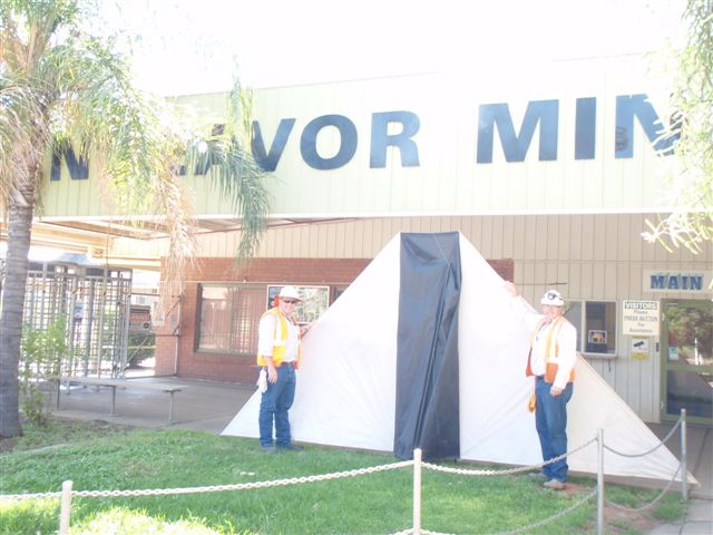
Below left: Conditions we flew in on 30th September. The winds increased throughout the day so the balloon flight did not show the 59 knots experienced at 12,700 ft. If we could have predicted these conditions we would have kept the kite on the ground. However, we did fly a kite in these conditions and I think we handled them as well as we could. There are some improvements to the winch and a new line set strategy for 2012. Given good conditions we will smash the record. Below right: Mine workers recovered the kite after the line break left the kite 19.2 km to the east.
22:00 EST
0900 30/09/11
+10 HRS or 0900 27/09
Image; Cobar Age newspaper.

2012
We will return to Cable Downs in late September to try our luck again and hopefully encounter good winds to high altitude. There are a number of changes planned that we think will increase our chances of reaching over 15,000 feet above ground level. We will have new Dyneema line from Cousin-Trestec in France courtesy of sponsorship from DSM Dyneema in Holland. I will make up different combinations of line strengths to better match conditions. I hope to have a hydraulic running line tensiometer made by Doug La Rock from the Kitebuilders forum in the USA. This will enable reel to reel testing of line. A disk brake will be fitted to enable the winch motor to be bypassed to reduce kite wing loads under high winds. The reel will have a drag brake fitted to prevent line overrun under free wheeling or sudden braking. the computer screen will have a light absorbing enclosure to aid clearer viewing of the screen in daylight. DSM want high resolution images of the kites for their product brochure and promotional literature.. An effort will be made to capture video footage from the kite for YouTube and the upcoming documentary.
We will return to Cable Downs in late September to try our luck again and hopefully encounter good winds to high altitude. There are a number of changes planned that we think will increase our chances of reaching over 15,000 feet above ground level. We will have new Dyneema line from Cousin-Trestec in France courtesy of sponsorship from DSM Dyneema in Holland. I will make up different combinations of line strengths to better match conditions. I hope to have a hydraulic running line tensiometer made by Doug La Rock from the Kitebuilders forum in the USA. This will enable reel to reel testing of line. A disk brake will be fitted to enable the winch motor to be bypassed to reduce kite wing loads under high winds. The reel will have a drag brake fitted to prevent line overrun under free wheeling or sudden braking. the computer screen will have a light absorbing enclosure to aid clearer viewing of the screen in daylight. DSM want high resolution images of the kites for their product brochure and promotional literature.. An effort will be made to capture video footage from the kite for YouTube and the upcoming documentary.
