Copyright © 2005-2019 by Robert Moore · All Rights reserved · E-Mail: droceretik@gmail.com
Hello, I'm Bob Moore.
I hope you find my website interesting. It's our story obout our quest to break the world altitude record for a single kite.
October 2005 on Cable Downs The 2 big DT Delta kites are 16 sq meters and 12 sq meters. The green and yellow delta is 2.25 sq meters. A 1.75 sq metre delta (purple & red) and a 8 sq metre Scott Sled (pink) rests on the ground.
10,466 ft
6,500 ft
3,250 ft
Starting in April 2005, a small group of kite enthusiasts, builders and expert flyers, made the 750 km trip to Cable Downs, a 20,000 hectare sheep station near Cobar in western NSW, Australia. The quest for the world altitude record for a single kite ended on the 23rd of October 2014. We flew flying big kites to high altitude culminating in capturing the Guinness World Record at 16,009 ft. above the altitude of the launch point. Our high flying kites have the authorisation from the Civil Aviation Safety Authority with the protection of an aircraft free zone up to 18,000 ft. This is nearly 1,500 ft. more than our target which was the previous record of Richard Synergy of Canada. We were permitted to fly up17, 370 ft. above ground level or 18,000 ft. above sea level and to reach that height would have been "icing on the cake" but we were very happy with 16,009 ft. This was a very difficult project and required patience, persistence, dogged determination, ingenuity and a fair bit of money. We were ultimately depending on the right wind conditions as we had solved most of the technical problems by 2011.
I would like to thank the people who have been involved, supported or shown interest in our record attempts including:
Michael Richards
Michael Jenkins
Roger Martin
Barry Coppenhall
Greg Moore
Hugh Moore
Steve and Karen Viant of Cable Downs for hosting the record attempts.
Robbie Buck of ABC 702 Local Radio
Nancy Shannahan of The Cobar Age
2DU radio
Daily Telegraph
David Horan - Australian Kiteflyers Society
DSM Dyneema for supplying line
Universal Instruments for the loan of theodolites
Lewis Pulleys for winch components
and countless kiting enthusiasts from around the world.
At 1,000 metres over the airstrip at Cable Downs the 12 sq metre DT delta October 2005 flys with a 2 metre eagle on a thermal. The eagle moved on to the northwest against the wind without flapping it's wings. A magnificient creature.
.
Some interesting facts and important issues
AGL: Above ground level. The kite's altitude must be measured from the altitude of the launch point. The sea level (AMSL) altitude is the reference for GPS units then the ground height above sea level is subtracted from AMSL to give height above the launch point. The air strip at Cable Downs is 630 ft or 192 metres above mean sea level (AMSL).
Elevation: The straight line angle to the kite compared to horizontal. Measured telescopically with a an astronomical telescope or a theodolite. Elevation an also be determine by GPS positional and altitude data.
Line angle: The angle of the line from horizontal at the point the line exits the last line guide or pulley. Line angle and line released cannot be used for accurately measuring kite altitude, particularly at high altitude. It is a reasonable approximation at altitudes below 200 metres if there is minimal line sag.
Angle of attack: The angle from horizontal the kite assumes when facing into the wind. It is the most at ground level before launch and the least when at maximum altitude. The bridle angle determines the initial angle of attack which may be between 7 and 12 degrees usually. The angle of attack is determined by lift and drag plus wind speed. Every kite has an ideal wind speed where kite weight, line weight, line drag and kite lift and drag are in equilibrium and produce a maximum altitude for that kite and line length.
AMSL: Above Mean Sea Level. The reference height for GPS and land survey. GPS devices measure altitude above mean sea level and the height of the flying field must be deducted from the GPS altitude to obtain the altitude above the launch point.
ISA air density: The standard worldwide air density at sea level at 20 deg C and 50% humidity. 1013.5 Mb of pressure. It is rarely precisely these conditions but forms the basis for calculations and instrument calibration. It is more important when using barometric altimeters. GPS altitude is not affected by changes in air pressure, temperature or density.
Lapse rate: The rate at which air density drops with altitude. A standard value at ISA standard temperature and pressure, 2.6% per 1,000 ft of altitude. ISA air density is about half sea level density at 20,000 ft. The wind speed must be double that of ground level to maintain the kites lift. However the line weight and drag requires greater wind energy as the kite rises.
Isobar: In meteorology, Lines on a map joining points of equal air pressure. The general reference for for wind flow direction, with some conventions for air flow moving from high to low pressure which changes the direction of the wind across isobars. Isobars closer together see stronger winds and wide pressure gradients see lower wind speeds. There are exceptions such as sea breezes and local topographic effects.
Jet Stream: Usually high speed narrow wind currents that form near polar areas and to a lesser extent, subtropical areas. They usually occur at altitudes between 30,000 and 40,000 ft. but may occur at lower altitudes. Not a problem for high altitude kite flying so far but could be in the future if exceeding 30,000 ft. with kite trains. So far the record wind speed is over 350 kph but is normally 120 to 160 kph. The highest speed record on my kite flights was 59 knots after a kite broke away at 12,000 ft. That is about 116 kph.
Catenary: The curve of a chain suspended at both ends under gravity. The approximate curve a kite line assumes without the effect of wind, i.e. an unequal height catenary. It is an invalid method of calculating kite altitude as line is not a freely suspended chain and the line's path may be distorted left or right by different wind directions at different altitudes.
Kite Drag: The wind force that pulls the kite parallel to the ground. Combined with kite liftthe resultant force produces line tension and kite flying angle.
Kite lift: The vertical force generated by air flowing against and over the kite. The magnitude is directly related to wind speed, angle of attack and kite type and lift area.
Line tension: Measured in lbs or kg and varies at the square of wind velocity. Doubling the wind speed at the kite quadruples the line tension. Line tension is a product of kite drag, kite lift and line drag.
Kite Line: A very important factor in record success or failure was the choice of kite line. It was clear that only the thinnest, lightest and strongest line would do the job. It turned out to be braided line made from UHMWPE fibres. Others were Aramid fibres such as Kevlar and Vectran. They are 40% heavier and slightly thicker than Dyneema/Spectra lines of the same strength. Dyneema was a little cheaper than Spectra but mostly it was due to shipping charges and line cost that I chose Dyneema over Spectra. It proved the right choice and it resulted in sponsorship from DSM Dyneema. Dyneema and Spectra are very UV resistant, abrasion resistant and low stretch. The downside is they have low melting temperatures and creep with sustained tension. These factors don't present a problem for our high altitude kite flights.
Dyneema: A very high strength synthetic fibre, made from ultra high molecular weight polyethylene (UHMWPE) that is braided into the kite line used for the record attempts. Made by DSM in Holland, the fibre was braided into our kite line by Cousin-Trestec in France. Line made by Amika in Taiwan used Dyneema fibres made by Toyobo in Japan.
Spectra: Similar to Dyneema fibre but made under licence from DSM by Honeywell in the USA and line manufactured from this fibre by various manufacturers such as Innotex and Twinline USA and Tasline, New Zealand.
GPS: Global Positioning System. A system of 24 satellites positioned in orbit above the earth that transmit signals to enable very accurate location of people objects and their velocities.
DGPS: Differential Global Positioning System. An augmented method of improving GPS accuracy for position and altitude. Most, if not all, GPS devices incorporate this technology and it allows accuracy of less than 10 metres for position and altitude as a minimum. In practice the accuracy is much better than that.
WAAS: The Wide Area Augmentation System is an air navigation aid developed by the Federal Aviation Administration to augment the Global Positioning System, with the goal of improving its accuracy, integrity, and availability. It is incorporated into most consumer GPS devices. The accuracy of GPS devices with this feature is 0.9 metres for position and 1.3 metres for altitude and this allows hands free landings in calm conditions in theory.
Telemetry: Literally, transmission of measurements. Any system that uses radio signals to transmit data between 2 points. GPS telemetry is used on the kite to transmit GPS positional data from the kite to the ground.
Theodolite: A precision instrument used by surveyors to measure terrestrial distances and angles. may be optical analogue (old instruments) or digital with laser beams
CASA: Civil Aviation Safety Authority. The Australian government body that makes regulations that govern all types of air transport and air sport activities.
Air Services Australia: The organisation that controls day to day flying activities including domestic flights, flight paths communication and air sports activities including NOTAMS
NOTAM: NOtice To Air Men. A system of warnings to pilots about possible hazards and restricted flying zones such as a kite altitude world record attempt zone.
Sonde: An instrument routinely sent aloft suspended under weather balloons at weather stations, often on a daily basis. The instruments transmit data via a telemetry transmitter and includes air pressure, altitude, wind speed, wind direction, temperature, humidity and time. The instrument may reach over 90,000 ft before the balloon bursts after expanding from a 1 metre diameter to over 10 metres. It is a very important aspect of high altitude kite flying that guides flight strategy and altitude expectations. Also the weather forecast will warn of storms which may cause cancellation of kite flights.
DT Delta: Dunton/Taylor version of a Conyne Delta Kite with a full cell triangular central box section and triangular delta wings. Alex Dunton is a well-known kite builder and designer. Hod Taylor was an elderly, almost blind man, who construct very large versions of Alex Dunton's kites. The record kites are DT deltas, 6.4 metre span and 2.8 metres tall and an effective sail area of 12.34 sq. metres.
Tensiometer: A device used to measure tension. On the kite winch, an hydraulic tension gauge was included in flights after 2009 and was built by Doug la Rock in the USA. It measured a maximum of 122 lbs of line tension in 2012 and 2014. Maximum line tension was about 40% of the breaking strength of the 300 lb Amika Dyneema line and about 30 % of the 350 lb
Cousin-Trestec Dyneema line. The gauge cylinder can tolerate up to 2,000 lb tension. The original gauge measured 200 lbs. An alternative gauge will measure up to 600 lb. A small Tensiometer is used on the bench to test small diameter lines. It has been adapted from testing leather products, shoe laces and cords.
Cameras: Still cameras with timers have been used occasionally to capture images from the kites. There is an image from over 2,000 ft. on this site. A digital time lapse camera may be used on future flights with capacity to capture 200,000 images and for these to be edited to produce a time lapse video at 5 second intervals. Video cameras have a problem with battery duration as some flights last over 12 hours. Go pro cameras have been suggested but their battery duration is insufficient. Video and still cameras have performed a vital role in recording the altitude record attempts and without the footage, the record evidence would be thin and the website and YouTube videos would not exist.
Media: While I have flown kites to high altitude and broken the world record for personal satisfaction, an intellectual challenge and as a creative outlet, I wanted to also share our achievements with the world for several reasons. Firstly I wanted to promote kite building and flying as a rewarding and interesting hobby. Secondly I wanted to expose the record attempts through the media so that I increased the chances of sponsorship to defray the costs of the series of record attempts. Thirdly, I am proud of my tenacity and achievement and I want to show to the world that this is what Bob Moore and his team have done. Most of the media coverage has been with local newspapers and radio. Papers include The Cobar Age, Dubbo Liberal, Hills Times, Sydney Daily Telegraph and The Sydney Morning Herald. Other media includes a Drachan Foundation article (kite magazine), Silicon Chip Magazine article online content. I have also been invited as consultant the Ion Power Group in the USA who are investigating ways of extracting energy from atmospheric Ions. One of these methods may involve tethered devices such as kites or balloons.
Sponsorship: I estimated that the altitude record attempts have cost about $80,000 over a 13 year period. This includes the testing, research and development that occurred even before any kites were flown at cable Downs. The costs would have been considerably higher if I had not received assistance through a number of individuals, businesses and companies. These include Kite Magic at Coogee in Sydney owned by my team member, Mike Richards. A major sponsor was DSM Dyneema in Holland who, through their line manufacturing partner, Cousin-Trestec in France, sent me 26 km of various Dyneema braided lines, a form of sponsorship. I estimate the value of the lines at about $15,000. Lewis Pulleys of Sydney, performed machining work and supplied winch parts at cost. TECO electric motors supplied winch motors at reduced prices. Universal Instruments of Lindfield in Sydney supplied theodolites each year of the record attempts free of charge. Mads Toft, Geophysics Engineer, certified GPS devices against spatial exchange benchmarks free of charge. Norman Hayes, registered surveyor certified GPS devices against Spatial exchange benchmarks free of charge. Doug La Rock, machinist and engineer and a Kite Builders forum member in the USA, generously custom built an hydraulic tension gauge probably worth $500 for parts and labour. Team members came on the record series at their own cost and time which I estimate to be worth $20,000. Their expertise was invaluable. The owners of Cable Downs, Steve and Karen Viant, hosted the World record attempts and their hospitality to have us stay in the wool shed using their power and a little bit of water was invaluable. Without this venue no high altitude kite flying was possible.


Left to right top: 1 Mike Jenkins on the airstrip 2009. The first night of camping we were washed out. 2 April 2005 from the winch version and the yellow Dyneema is Amika's 300 lb braided line. Excellent quality. 3 April 2005 and the Sydney Morning Herald flew in a reporter to take pics.
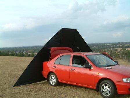
Bottom: 4. The black 12 sq. metre DT delta at about 500 metres. The thickness of the line is exaggerated by the camera's focus on the kite. 5 October 2005 and Greg Moore takes a pic as I land the kite perfectly after an aborted 4,000 ft. flight in hot dry conditions. Shortly after this kite was lost forever 25 km to the east in rugged bushland. 6 We used theodolites for observation on most series of attempts. They were to be used for triangulation measurement of the kite's altitude but clouds and other factors precluded their use. Nice instruments. 7 Line guide "horn" in the foreground and 12 sq. metre DT Delta flying at a few hundred metres. 8 The Nissan Pulsar on Rooty Hill with the first DT delta which was lost in at Cable Downs in October 2005.
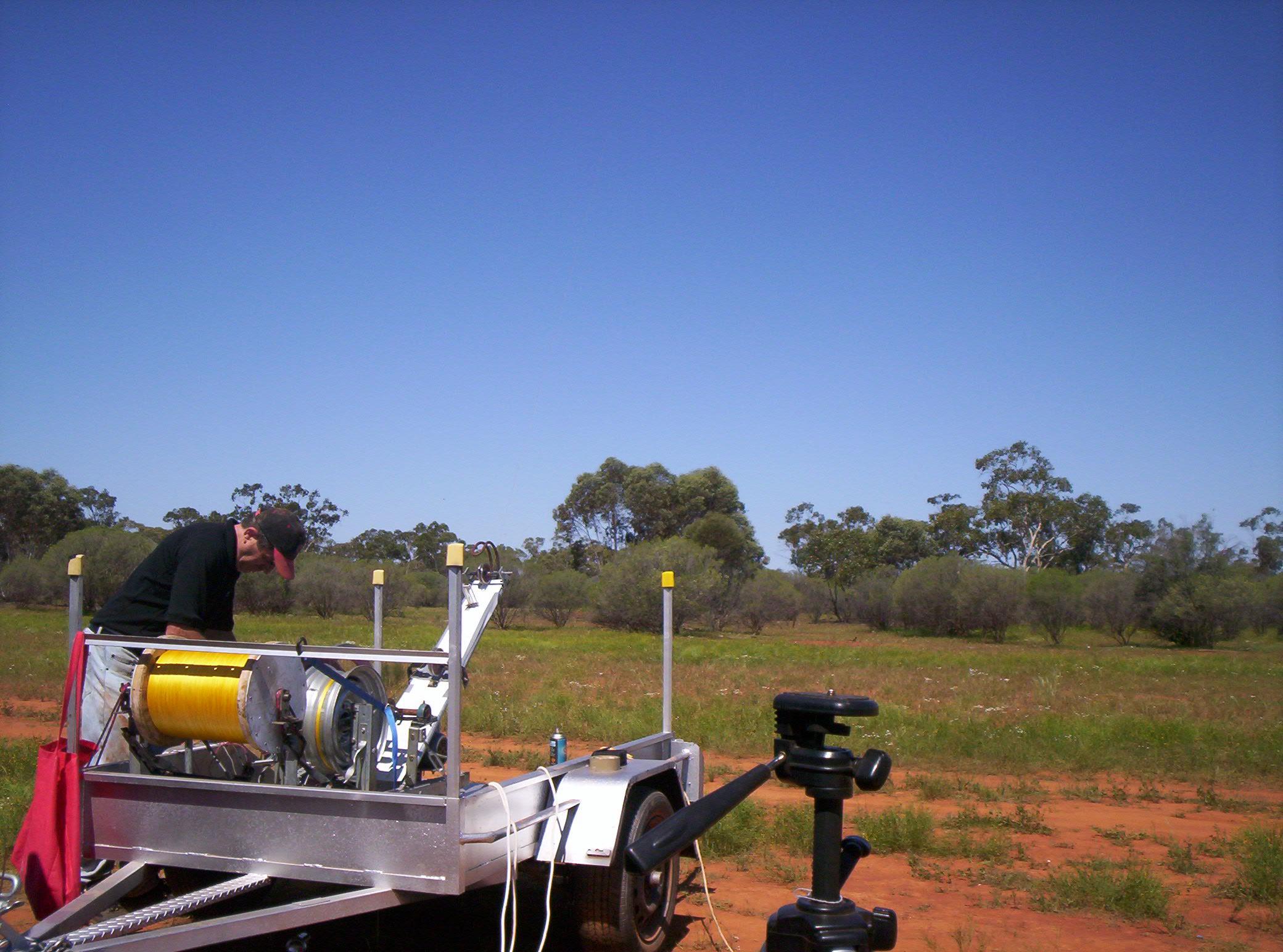
The trailer evolved as the record progressed. It is a 6 ft x 4 ft box trailer, could have been a little bigger and deeper but my original car was a small sedan so the towed weight was limited. I built the winch and did the trailer mods and graphics.
FOR ALL YOU KITE NEEDS VISIT http://www.kitesite.com.au/
Kite Altitude World Record